Before you head out on your adventures, please remember to check the Important Updates and Site Marker Post Status pages for any changes to hikes, directions, or parks. You can also check the Get Outdoors York! Facebook page for information.
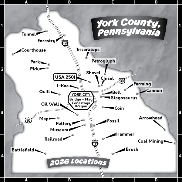
NOTE: For an interactive map, please visit the Site Marker Hikes page and click on the blue "Locations Map" button. individual site marker pages also contain specific GPS coordinate locations.
Due to a summer-long bridge closure/replacement on Route 74/Carlisle Road north of Dover, new alternative directions have been provided for some parks.
137 Eastern Boulevard, York, PA 17402
Hours: Dawn to dusk
Directions to Parking Area: Head east on E Market Street (PA-74/PA-462) to Cinema Drive (about 2.5 miles after you cross under I-83). Turn right and follow Cinema Drive to Eastern Boulevard. Turn left on Eastern Boulevard and travel to the park entrance on right.
Hours: 8am to dusk, unless posted
Directions to LaHo Trailhead Parking Area: Follow Route 30W to the new Wawa. Turn left on Route 116 toward Hanover. After about 12.0 miles, turn left on Route 216 (Blooming Grove Rd.). Follow Route 216 S past the Park Office on your left. After crossing the second bridge, turn right into the LaHo Trailhead Parking Area.
201 N US Route 15, Dillsburg, PA 17019
Hours: Dawn to dusk
Directions to Parking Area: Follow I-83 N to Exit 32/Route 382 Newberrytown. Turn left off the ramp, follow Route 382/Lewisberry Road for 3.7 miles, and turn left on Route 177/Rosstown Road. Stay on Crosstown Road for about 6.0 miles until you reach the intersection with Route 74. Turn right at the signal (Old York Road) and continue for 7.3 miles to E Harrisburg Street. Turn left on Harrisburg Street, then right on N Baltimore Street. Turn sharp left on US-15 S. The park will be on your right in 0.3 miles.
Hours: Dawn to dusk
Directions to Parking Area: Travel east on Route 462/E Market Street to Route 24 (Mt. Zion/Edgewood Road) Turn right on Edgewood Road and continue for 1.3 miles to the signal at Route 124/Prospect Road. Continue straight across on Cape Horn Road for 2.0 miles. Turn right on S. Sharon Avenue. The parking area will be on the left, across from Fitz Park, in about 600 feet.
Hours: 8am to dusk, unless posted
Directions to Boat Mooring Area #3 (Park): Follow I-83 N to Exit 32/Route 382 Newberrytown. Turn left at the bottom of the ramp and follow Route 382/Lewisberry Road for 3.7 miles. Turn left on Route 177/Rosstown Road. Continue for 2.5 miles to Alpine Road and turn left. Continue for 1.6 miles to the entrance to Boat Mooring Area #3 on the right. Follow the park road to the parking area by the lake.
Directions to Conewago Day Use Area (Pick): Follow I-83 N to Exit 32/Route 382 Newberrytown. Turn left at the bottom of the ramp and follow Route 382/Lewisberry Road for 3.7 miles. Turn left on Route 177/Rosstown Road. Continue for 2.5 miles to Alpine Road and turn left. Continue for 2.3 miles to the entrance to Conewago Day Use Area on the right. Follow the park road to the day use parking area. Turn left at the large billboard and park close to the Environmental Learning Center at the far end of the parking area.
Hours: 8am to dusk, unless posted
Directions to Hanover Junction Parking Area (Railroad): Follow the Route 30 Bypass west toward Gettysburg. After exiting the ramp, proceed to the left turn lane at the next intersection. Turn left on Trinity Road/Route 616 and continue south for about 5.7 miles, passing through York New Salem. When you reach Seven Valleys, follow signs for Route 616 S toward Glen Rock and take the second right (at McGrew’s Auction) on Seven Valleys Road. Continue about 1.3 miles to the parking area on your left.
Directions to Loucks Mill Road Parking Area (Bridge): From Route 30, turn right on Loucks Mill Road. The entrance to the parking area is about 100 yards ahead on the right.
16535 Althouse School Road, Stewartstown, PA 17363
Hours: Dawn to dusk, unless posted
Directions to Parking Area: Take I- 83 S to exit #4 (Shrewsbury). Turn right off the exit (on Route 851 W) and proceed 0.3 miles to Mt. Airy Road on your right. Turn right on Mt. Airy Road and proceed about 1.0 miles to Plank Road. Turn right on Plank Road and go 3.1 miles to Althouse School Road. Turn left and continue 0.25 miles to a paved parking area on the right.
205 Indian Steps Road, Airville, PA 17302
Grounds dawn to dusk, unless posted
Directions to Parking Area: Follow Route 74 S toward Red Lion. Once you reach the square in Red Lion, continue on Route 74 S 1.5 miles to Burkholder Road. (Mack’s Ice Cream). Turn left on Burkholder Road. Follow to New Bridgeville and Route 425. Take Route 425 S, about 6.3 miles (just past Otter Creek Campground). Stay straight on Indian Steps Road. The parking area will be on your left in about 0.6 miles.
Hours: 8am to dusk, unless posted
Directions to Parking Area: From Route 30, follow Mount Zion Road/Route 24 north to Sherman Street. Turn right on Sherman Street and then left on Mundis Race Road (after the bridge). The park is 0.6 miles on your right. Park at the Pines Picnic Area to start your hike.
Hours: Dawn to dusk, unless posted
Directions to Parking Area: From W Market Street, follow S Richland Avenue toward Indian Rock Dam Road. Turn right and continue through the underpass. Turn left before crossing the bridge to stay on Indian Rock Dam Road. Turn right on Croll School Road and continue to Days Mill Road, bearing right and continuing to the park entrance on the left (past the Rail Trail parking area). Park in front of Field #1.
Long Level Road, Wrightsville, PA 17368
Hours: 8am to dusk, unless posted
Directions to Parking Area: Take Route 30 E to the Wrightsville Exit. Turn right on Cool Springs Road toward Wrightsville. Continue straight on Cool Creek Road at the signal (Golf Course will be on your right.) Drive about 1.7 miles to Knight’s View Road. Turn left and continue for 1.5 miles. Turn right on Route 624 S and travel about 1.7 miles to Klines Run Park. Park in the lower parking area in front of the pavilion.
Hours: Dawn to dusk, unless posted
Directions to Parking Area: Follow Route 74 north toward Dover. From the intersection where Route 74 travels under Route 30, continue about 3.0 miles to Davidsburg Road. Turn left on Davidsburg Road and continue about 0.6 miles to Lehr Unity Park and the Dover Township Community Building on the left side. Park near the entrance to the soccer fields and the pavilion.
River Road, Airville, PA 17302
Hours: 8am to dusk, unless posted
Directions to Parking Area: Follow Route 74 S/S Queen Street toward Red Lion. Continue on Route 74 (Delta Road) south toward Delta. After travelling about 15.5 miles on Route 74, turn left on Route 372 (Holtwood Road). Remain on Route 372 east to Norman Wood Bridge. Turn left on River Road just before the bridge. Continue to the second parking area on your right.
Hours: Dawn to dusk, unless posted
Directions to Parking Area: Follow Market Street/Route 462 east to Edgewood Road. Turn right on Edgewood Road, then turn left on Edenbridge Road. Entrance to the parking area will be about 0.25 miles on your right.
5922 Nixon Drive, York, PA 17407
Hours: 8am to dusk, unless posted
Directions to Parking Area: Take I-83 S to the Leader Heights exit (#14). At the end of the ramp, turn right and follow Leader Heights Road to S George Street. Turn left on S George Street toward Jacobus. After passing Smith Village, turn right on Valley Road and follow down the hill. At the sharp right curve, turn right on Nixon Drive. At the stop sign, turn left. The Wetlands Parking area will be right after the turn to your left.
Deininger Road, York, PA 17402-9781
Hours: 8am to dusk, unless posted
Directions to Park Entrance: From Route 30, take Mount Zion Road (Route 24) north for 1.0 miles. Turn right on Deininger Road and follow it into the park.
Back Parking Area (Chisel): Follow the road to the back parking area under the powerlines.
Wildlife Picnic Area (Shovel): The parking area will be on the right.
Hours: 8am to dusk, unless posted
Directions to Parking Area: Take I-83 N to exit #39A (Lewisberry Road/Route 114). At the end of the exit ramp, turn left, cross over I-83 and continue on Lewisberry Road about 1.8 miles to the park on your right.
6000 Mount Pisgah Road, York, PA 17406
Hours: Dawn to dusk, unless posted
Directions to Parking Area: Take Route 30 East (toward Lancaster) and follow to the Wrightsville Exit. Turn right at the end of the exit ramp – this is Cool Springs Road. Follow Cool Springs Road as it crosses Route 462 (Lincoln Highway) and turns into Cool Creek Road. Cool Creek Country Club will be on your right. Continue on Cool Creek Road about 1.5 miles to Mount Pisgah Road. Turn right on Mount Pisgah Road and turn left at the entrance of Samuel S. Lewis State Park. Park in the first parking area to start your hike.
420 Cassel Road, Manchester, PA 17345
Hours: 8am to dusk, unless posted
Directions to Parking Area: From downtown York, follow N George Street about 9.1 miles to Conewago Avenue (across from the Conewago Inn). You will cross Route 30 and proceed through Emigsville and Manchester Boroughs. Turn left on Conewago Avenue and follow about 0.9 miles to Cassel Road. Bear left on Cassel Road and follow another 0.9 miles to the park on your right.
Hours: Dawn to dusk, unless posted
Directions to Cross Roads Parking Area: Take I-83 S to exit #8 (Glen Rock). At the end of the exit ramp, turn left on Rt. 216 (Seaks Run Road). After going under the highway, turn right on Potosi Road and follow about 2.6 miles to the Cross Roads parking area. This is the parking area at the junction of Blymire Hollow Road, Potosi Road, and Sunlight Drive. You will have crossed over the Codorus Creek.
2370 Kayla Boulevard, York, PA 17406
Hours: Dawn to dusk, unless posted
Directions to Parking Area: From Rt. 30 (near I-83), turn north on Susquehanna Trail. Remain on Susquehanna Trail for about 1.5 miles to Stillmeadow Lane. Turn left at the stop light and continue on Stillmeadow Lane for 0.3 miles to Kayla Boulevard. Turn left on Kayla Boulevard and travel 0.2 miles to Kyle Road. Turn left on Kyle Road and travel to the parking area at the end of the road.
Hours: Dawn to dusk, unless posted
Directions to Parking Area: From downtown York, follow E Philadelphia Street for 1.2 miles. Turn left on Carlisle Avenue and then turn right on W Market Street for 4.6 miles. Turn left on PA-116 W/Hanover Road for 2.1 miles. Turn left on S Alpine Drive. Turn left on Mineral Drive and then turn left on Ledge Drive. Turn right on Mesa Lane to the park on your left.
Hours: Dawn to dusk
Directions to Parking Area: Travel east on Rt. 30 from York and take the Hallam exit. Turn left from the ramp on Kreutz Creek Road and travel for about 2.0 miles, following the road as it curves sharply left and right. Just after you pass Spring Road on the right, turn right on Tower Road. Continue for 1.2 miles. Turn left on Furnace Road/SR 1008. The park entrance is 0.2 miles ahead. Park in the second parking area, which is about 1.2 miles into the park.
Hours: Dawn to dusk, unless posted
Directions to Parking Area: From York, follow S George Street to Rathton Road (near York Hospital). Turn left on Rathton Road and continue across S Queen Street. Turn left on Edgar Street and proceed to the first stop sign. Turn right on Rockdale Avenue and proceed straight into the parking area. Park in the first area on the right near the Gold Star Healing & Peace Garden.
Hours: 8am to dusk, unless posted
Directions to Lake Redman Parking Area (Fossil):Take I-83 S to exit #14 (Leader Heights). Turn right and follow Leader Heights Road to S George Street. Turn left on S George Street toward Jacobus and continue for approximately 1.9 miles. Turn left on Church Street and continue until you get to the stop sign at Ironstone Hill Road. Turn right, and after about a mile, you will get to Log Road. It is a sharp right turn. The parking area will be right after the turn on your left.
Directions to Lake Williams Parking Area (Pottery): Take I-83 S to the Leader Heights exit (#14). Turn right and follow Leader Heights Road to S George Street. Turn left on S George Street, then make an immediate right on Reynolds Mill Road. Follow Reynolds Mill Road for about 1.75 miles to Water Street. Turn left and continue to the parking area on the left before the gate.
347 Woodbridge Drive, Etters, PA 17319
Hours: Dawn to dusk, unless posted
Directions to Parking Area: Take I-83 N to the Lewisberry exit (Exit 35). Turn right on Salem Road. Take the first left on Wyndamere Road (PA-177). Stay straight to go on Valley Road. (PA-262). Turn left on Beinhower Road. Take the second right on Woodbridge Drive. The parking area will be on your left.
Hours: Dawn to dusk
Directions to Keystone Kidspace Parking Area: From downtown York, follow N George Street to Hamilton Avenue and turn right. Go past Keystone Kidspace on your right and look to the left for Keystone Kidspace parking area.
